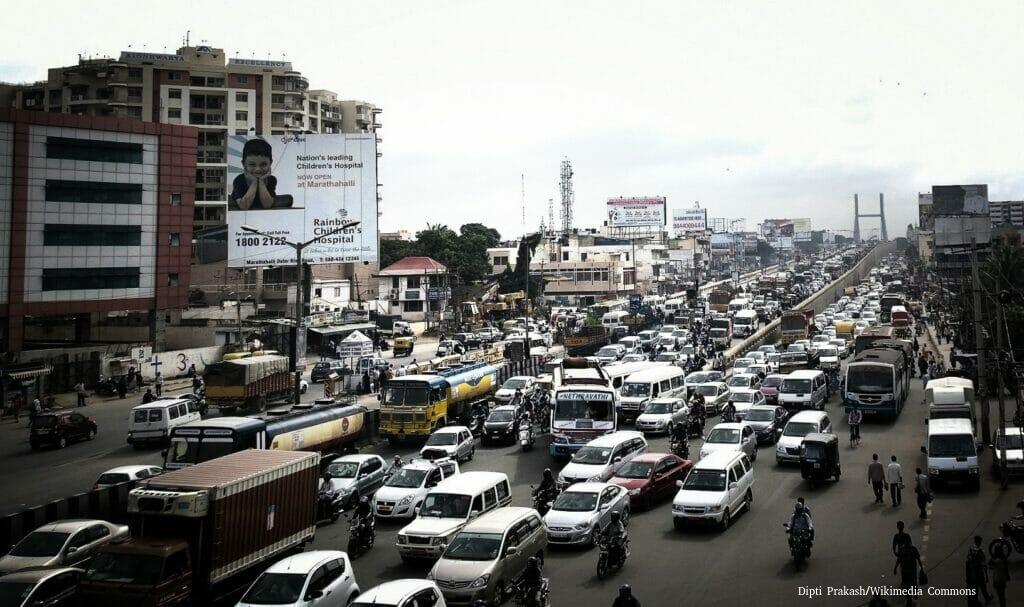
Road infrastructure is a crucial component of a city’s infrastructure as it facilitates the movement of people, goods and services throughout the city. It is all the more important for a city like Bengaluru for two major reasons.
First, unlike other cities of comparable size, in India or globally, Bengaluru does not have a suburban rail network/MRTS covering all parts of the city, with Namma Metro having limited coverage. As a result, almost the entirety of the city’s transit takes place on its roads with cars, two-wheelers, autorickshaws, buses, trucks, and cycles dependent on it.
Second, Bengaluru has witnessed unprecedented levels of urban growth and sprawl over the past two decades; therefore, the road network plays a crucial role in accessing these newly urbanized areas.
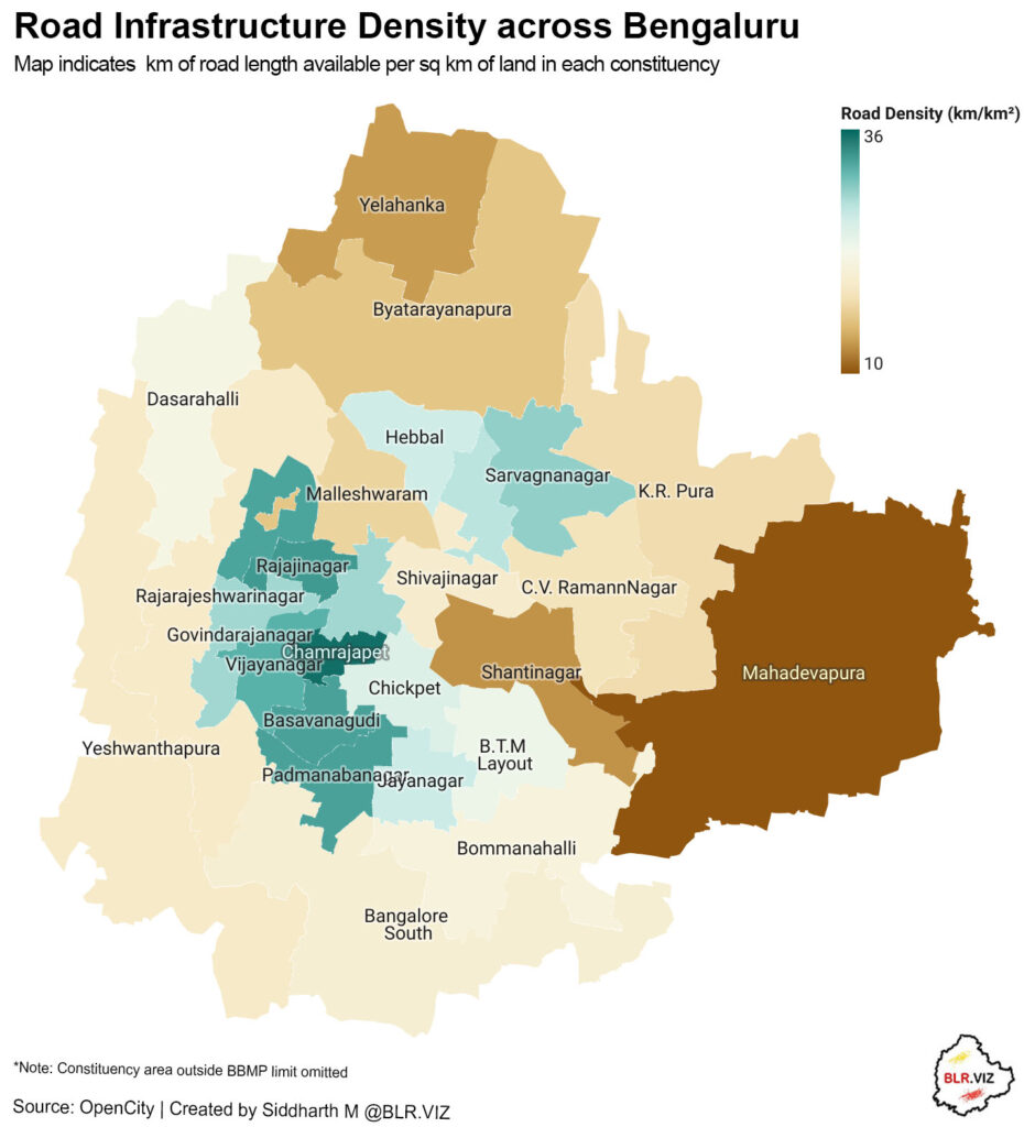
This article tries to analyse the road infrastructure density, i.e., the road length per sq. km, at the constituency and ward level for Bengaluru. Road density reveals interesting insights about a city, such as the urban planning pattern, and accessibility. However, one must be cautious not to interpret the maps purely to justify infrastructure inadequacy and build more roads, as such a measure can contribute to ‘induced demand’, leading to more vehicles on the road.
Constituency Level analysis
Not all roads lead to equity: some Bengaluru constituencies have far denser networks than others. Central and western constituencies like Chamarajpet, Rajajinagar, Basavanagudi, Mahalakshmi Layout, Padmanabha Nagar, and Vijayanagar have the densest road networks, boasting between 30 – 35 km of roads per sq km. This high number could be attributed to the fact that these constituencies are some of the oldest areas in Bengaluru and have close proximity to the Central Business District (CBD).
In contrast, Mahadevapura and Shantinagar have the lowest road density of 10 to 13 km of roads per sq km. It is interesting that the largest eastern constituency of Mahadevapura shows very low road density despite being an IT hub. The large variation between the western and eastern constituencies indicates different levels of accessibility and connectivity across the city.
Ward Level analysis
When analyzed at ward level, the highest concentration of road infrastructure density is around the central western and central north eastern wards, reflecting the map at constituency level.
Wards like Nilasandra, Shivajinagar, Chickpete, and Dayandanagar boast the highest road density, ranging between 50 and 60 km of roads per sq km. On the other hand, wards like Jalahalli, HAL Airport, and Agaram show the least road infrastructure density with 3 to 6 km of roads per sq km.
Peripheral constituencies/wards show lower densities compared to inner constituencies/wards, which may also indicate newer developments or areas that have not been fully urbanized. This pattern also indicates that while central Bengaluru has mature connectivity of roads, peripheral areas may face accessibility challenges, possibly impacting or creating mobility challenges for commuters in these areas.
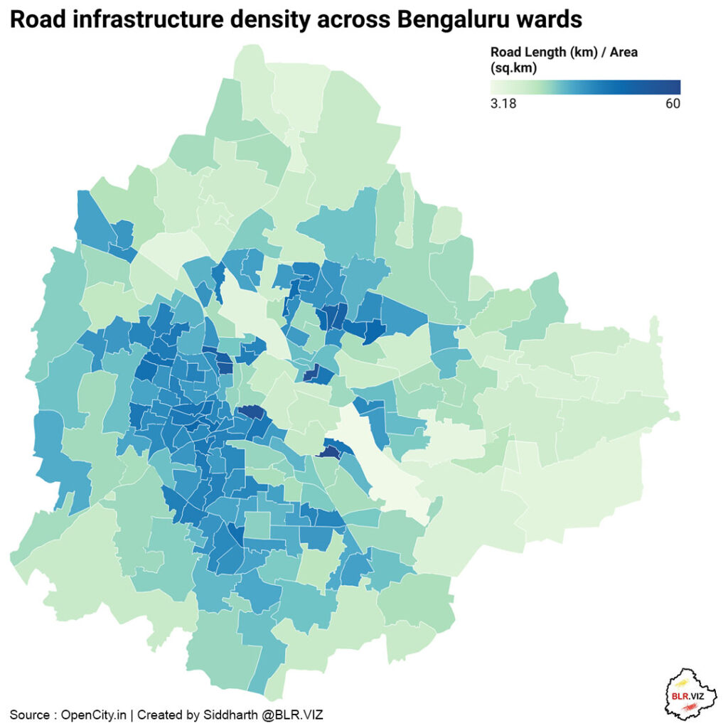
This analysis is based on the ward level dataset available through OpenCity.in data portal, while ward and constituency boundaries were sourced from Bengaluru GIS portal
For Constituency level mapping, Constituency areas outside BBMP limits have been trimmed only to retain those areas for which data was available, hence the following constituencies do not retain their official boundaries – Yelahanka, Yeshwanthpura, Mahadevpura, Byatarayanapura, Bangalore South.