Bangalore… one of the fastest growing cities, also known as India’s Silicon Valley, and a house of more than two million IT workers.
Bengaluru, as it has been officially called since November 2014, is the hub of the US$ 45 billion information technology sector that contributes nearly 38% to India’s GDP.
In fact, Bengaluru has become such a powerful city that foreigners dread the term Bangalored– which means losing your job in the west. People from all over India flock here to get a job, earn a good living and enjoy a decent lifestyle. The expansion has been so great that it has grown twice its size in the past 40 years.
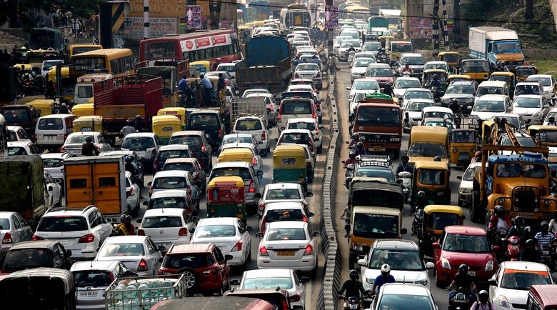
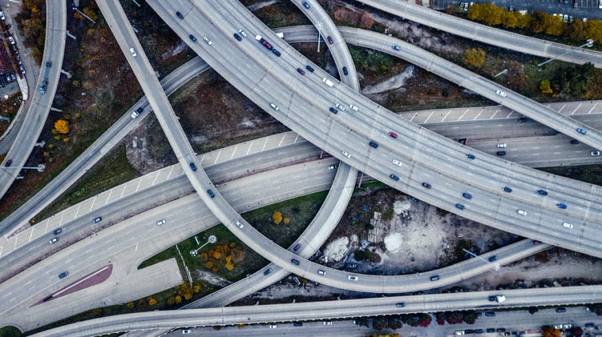
However, this rapid expansion has come at a hefty price. There has been a 6000% increase in the number of vehicles on streets since 1990. And this humongous rise in vehicles have given rise to monstrous traffic. This problem has now become so great that people have started getting anxiety attacks from just the thought of driving to work.
In the last 15 years, the rate of movement of traffic has come down from 40 km/hour to 9 km/hour.
But.. wait a second, do you think population is the reason for this distressing condition of traffic? Or is it something else? Our research reveals some interesting findings.
Is population the reason?
I started with asking myself a question, if population is the reason for traffic, then cities with the highest population densities should suffer from similar problems.
The below picture shows live traffic in four most populated cities in the world on a Saturday evening.

Following are the stats for people living per sq. km for the four cities:
1. New York : 10,200 people/km²
2. Washington : 9,800 people/km²
3. Chandigarh : 9,500 people/km² (approx.)
4. Bangalore : 6,000 people/km² (approx.)
However, when I observed the traffic condition in the other three, they showed almost no signs of traffic congestion. And on the contrary, Bengaluru, which has lesser population density than the other three, was traffic blocked.
Is city plan the reason?
Once the population was eliminated from the list, I jumped to the next probable cause.
I studied the plans of the above four cities and it revealed some intriguing findings. I observed that all the well planned cities in the world followed a Grid pattern where the roads run parallel and across each other. While Bengaluru followed a Star pattern. (except in layout areas)

Grid pattern has an inherent benefit, that to go from point A to point B, you have multiple paths and the traffic gets distributed.

Whereas, in the Star pattern there is almost always just one (or two) main ways to go from point A to point B which congregates the traffic coming from sub-streets onto one main road.

Star pattern is the result of rapid-unplanned growth. And the worst part is the main roads are not wide enough to accommodate the traffic coming from various sub-streets. This causes huge traffic jams on main roads while internal streets remain completely desolate — ineffective distribution of traffic.
Any other reasons?
Other than these, I also found some other reasons which contribute significantly in making Bangalore traffic worse.
- Common Office/School timings: School and offices use busses for their employees and students respectively. These busses come on the streets at similar timings and cram the traffic.
- Cars: Most IT professionals use cars to travel to work. This takes up a lot of space per person on already narrow streets.
- Ineffective public transport: The reason people use cars is because, the public transport is inefficient.
- Vicinity of IT parks: Major IT parks in Bangalore are located on single belt, which makes the matters worse on the Bangalore roads.
- Us: Yes. Even we are responsible. I agree, there is inefficient traffic management; but if we would follow road discipline ourselves, the situation could become a lot better.
With 7.5 million vehicles on roads every day, how do we handle the situation?
Simple Solution
The only way to handle the current traffic problem is a well-connected metro/public transport system. I do agree with the point, and in fact, a well-connected metro network would alleviate the traffic problem and is a necessity, however at the same time, I also believe thinking of it as the only solution would limit us to this belief and would prevent us from looking into other ways of handling the problem.
Different Vehicles, Different Affordances

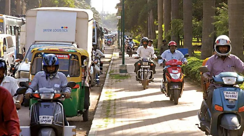
Have you ever come across this scene? If you live in Bangalore and ride a two-wheeler, I’m pretty sure at least once you would have participated in the activity as well!
Two-wheelers continue to dominate the Bengaluru roads, accounting for 70% of its total vehicular population, followed by cars (19%). Heavy vehicles like buses, trucks, and cars prevent smaller vehicles like two-wheelers from moving past. Two-wheelers can afford to pass through smaller spaces in traffic congestion. But having just one common lane for all the vehicles; riders often cut through dangerously between the trucks and cars to move speedily. I have often come across situations where, as soon as the riders find a little gap between the heavy vehicles, they keep moving past the heavy vehicles, stopping them from moving ahead. This impedes the traffic behind them and creates a blockage. And when there is not enough space to cut through, riders often drive on the footpaths making it unsafe for both, the rider and the pedestrians.
In Bengaluru, we have different types of vehicles and both have their own affordances. The vehicles which are smaller can move faster and should not be made to wait due to the vehicles which afford more space and move slowly. In this case, creating something as simple as a psychological separation for two-wheelers (wherever possible) can significantly improve the situation.
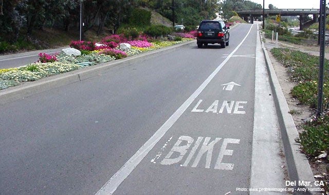
Two-wheelers, autos move faster compared to four-wheelers, buses and trucks; so, it would help if we have separate lanes, so they can move quickly without blocking the traffic and riding dangerously.
Now the question is, will this thing actually work and will people actually follow it? Many of the things that work in other countries fail when implemented in India, or people use it in a completely different way. So, the only way of knowing is to try it out!
Exasperating Traffic, Intelligent Traffic Lights.
In a study conducted by Stockholm Transportation Dept, it was found that traffic congestion shows an exponential nature.
That means, traffic congestion at one junction, propagates exponentially. Fortunately, it works the other way as well. If you clear a certain part of congestion, the traffic clears up faster than you would expect.
Initially, traffic lights were introduced to ease congestion and bring order on what otherwise would be a dangerous intersection of roads. But believe it not, traffic lights nowadays are causing much of the traffic jams.
In fact a new research by DailyMail suggests that much of the traffic jams are caused by traffic lights.
When all of the traffic lights went out on one of the most heavily trafficked roads in Britain the traffic moved smoother with lesser congestion.
Ineffective traffic signals cause more nuisance than service.
One way to look at it is this- Quantum theory of Traffic
Traffic moves in quants or chunks. And every chunk has its own momentum. The more often this momentum is altered, the slower it moves and the slowness is caused by the change, not the number. Which means, if you are traveling on a straight road with five to six traffic signals on the way, the signals should be designed in such a way that when one chunk of traffic leaves one signal, the signal ahead of it becomes green when the chunk reaches there.
We need traffic signals that collect data from all directions and adjust the signal timing accordingly so, chunks of traffic flow smoothly on the roads without much alteration in the momentum. It is referred to as Intelligent Traffic System (ITS).
This system has been implemented in Japan and has given positive results.
(Good news: India is soon going to import ITS technology from Japan and implement it in 29 junctions in Bengaluru to test out the system.)
Varying Traffic, Adaptable Lanes.
This concept is purely a result of personal observation. Usually, I have observed, most of the traffic flows in one direction. As a result, one of the lanes is heavily populated and the other very little.
On the roads where there is no physical separation between the lanes, the lane in which traffic is greater pushes the vehicles and takes up space in the other lane. However, when the width of the lanes is fixed, results in heavy traffic on one side and very little on the other.
This behavior could be the result of several factors like common office timings, vicinity of tech parks etc.
How about having adaptable lanes that alter their width and give more space to the lane which has more traffic density according to the time of the day.
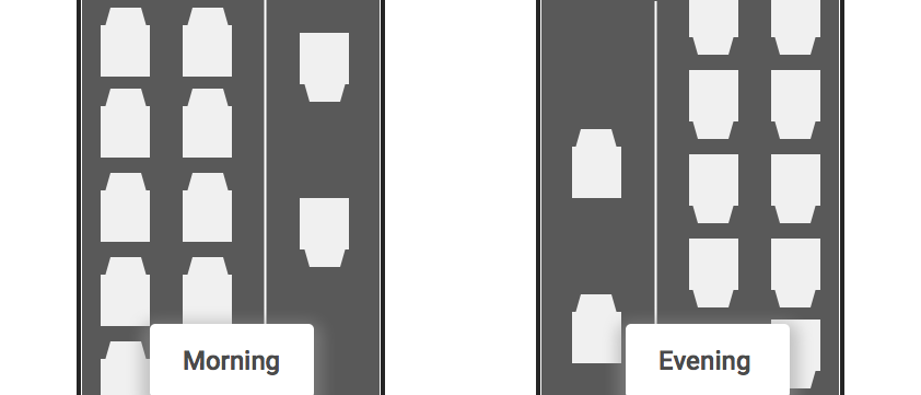
This will help to better utilize the existing real estate, as traffic on both sides doesn’t require equal space all the times.
This idea is still in its conceptual level and I haven’t yet explored the implementation details. A similar concept referred to as Modular Lanes exists but the idea is still in its infancy.
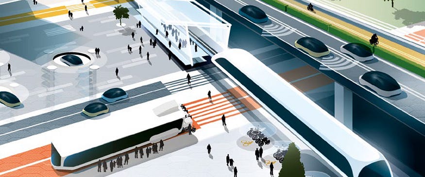
Digital solution
One solution to traffic congestion is smart mobility. Smart mobility is the concept of connecting the elements of a city’s transportation system to the cloud. Data from each element — vehicles, traffic signals, people, roads, and maps-is collected, combined, and analyzed to optimize the flow of vehicles in the city.
If we drill down on how cities are using smart mobility to reduce traffic congestion today, we see best practices emerge. Let’s look at six key items that cities should embrace to enable smart mobility solutions.
To learn how Microsoft can help you get started with smart mobility, explore these resources.
Connected infrastructure
One criterion required to enable smart mobility to reduce traffic congestion is connected infrastructure. The different parts of a city’s transportation system need to be connected to the cloud: traffic lights, cars, buses, trains, bikes, people, maps, and even roads. This Internet of Things (IoT) approach allows location, speed, capacity, and other data to be collected, stored, and analyzed. Wilson Parking recently invested in connected infrastructure to decrease congestion for drivers using the new Hong Kong-Zhuhai-Macau Bridge. The city of Taipai has launched an initiative to connect 150,000 streetlights.
Access to data
Another criterion is access to data. Cities continuously collect and produce large quantities of data for planning, production, and decision-making. Sharing this data with the private sector can help accelerate smart mobility solutions. The City of Denver creates a holistic data environment that brings together data from multiple siloed sources to meet its smart mobility goals. Helsinki, Finland, opened access to city GIS transportation data.
Alternative transportation
A third criterion is offering compelling options to the “one car, one driver” model. For smart mobility, alternative options would need to be connected to the cloud:
- Bicycle commuting: ideal for commutes of a few miles
- Carsharing: rent cars by the minute or by the hour
- Ridesharing (carpooling): make use of the empty seats already in the system
- On-demand ride services: use personal vehicles to offer transportation services
- Buses and trains: reimagining existing transportation by integrating them into end-to-end trip plans, including how to travel the last mile home
Autonomous vehicles
A fourth criterion required to enable smart mobility to reduce traffic congestion is the evolution of autonomous vehicles. While still in development, autonomous vehicles are cars or trucks in which human drivers are not required. These vehicles use sensors and software to control, navigate, and drive the vehicle. The use of autonomous vehicles to reduce traffic congestion depends on public policy. For example, self-driving cars could connect transit hubs, provide public transit services to communities not currently served, and be used to improve public transportation.
Traffic management
Traffic management is ultimately at the heart of reducing congestion. The new Hong Kong-Zhuhai-Macau bridge is a modern-day marvel that has forever changed traffic patterns across one of Asia’s fast-growing areas. Recent estimates say daily volume on the world’s longest sea bridge will reach 29,100 vehicles by 2030 and 42,000 vehicles by 2037. Wilson Parking enables drivers to pre-book spaces on the bridge, resulting in smoother traffic flows. The City of Denver uses its capabilities to take a proactive approach to transportation optimizations, for example, by enabling real-time adjustments to traffic flows in the case of accidents or other disruptions.
Mobility as a Service (MaaS) Applications
Mobility as a Service (MaaS) applications complete the smart mobility picture. The vision of MaaS is to make it easier and less expensive for car drivers and passengers to travel via alternative forms of transportation. MaaS applications enable travelers to plan trips based on their priorities and preferences. Microsoft is working with companies like Moovit and TomTom to offer critical real-time data to MaaS application providers, enabling them to deliver compelling applications.
By connecting traffic lights, vehicles, people, and roads to the cloud, sharing data, embracing alternative modes of transportation, and building traffic management systems, cities like Hong Kong, Taipei, and Denver are experiencing success and leading the way for other cities. As travelers adopt MaaS applications, they will increasingly choose mass transit options over driving on their own. The advent of autonomous vehicles will eventually help reduce traffic congestion even further.
What is Intelligent Transport System and how it works?
With the conception of smart city transmuting cities into digital societies, making the life of its citizens easy in every facet, Intelligent Transport System becomes the indispensable component among all. In any city mobility is a key concern; be it going to school, college and office or for any other purpose citizens use transport system to travel within the city. Leveraging citizens with an Intelligent Transport System can save their time and make the city even smarter. Intelligent Transport System (ITS) aims to achieve traffic efficiency by minimizing traffic problems. It enriches users with prior information about traffic, local convenience real-time running information, seat availability etc. which reduces travel time of commuters as well as enhances their safety and comfort.
The application of ITS is widely accepted and used in many countries today. The use is not just limited to traffic congestion control and information, but also for road safety and efficient infrastructure usage. Because of its endless possibilities, ITS has now become a multidisciplinary conjunctive field of work and thus many organizations around the world have developed solutions for providing ITS applications to meet the need.
One such example is the city of Glasgow. In the city, Intelligent Transport System gives regular information to the daily commuters about public buses, timings, seat availability, the current location of the bus, time taken to reach a particular destination, next location of the bus and the density of passengers inside the bus.
Iain Langlands, GIS and Data Manager, Glasgow City Council explains, bus operators in the city have the sensors in their buses. So, if the bus is going to be early to the next bus stop the bus is temporarily and very slightly is slowed down at the red light little longer than it should be to make sure the bus is on time and do not ahead of the schedule”. The system has been designed so smartly that passengers and even drivers are unaware of the delay as they are very little delays.
Application areas of Intelligent Transport System
The entire application of ITS is based on data collection, analysis and using the results of the analysis in the operations, control and research concepts for traffic management where location plays an important role.
Here sensors, information processors, communication systems, roadside messages, GPS updates and automated traffic prioritization signals play an imperative role in the application of:
- Advanced Traffic Management System
- Advanced Traveler Information System
- Advanced Vehicle Control system
- Advanced Public Transportation System
- Advanced Rural Transportation Systems
- Advanced Commercial Vehicles Operations system
How Intelligent Transport System works?
Traffic Management Centre (TMC) is the vital unit of ITS. It is mainly a technical system administered by the transportation authority. Here all data is collected and analyzed for further operations and control management of the traffic in real time or information about local transportation vehicle.
Well-organized and proficient operations of Traffic Management Centre depends on automatized data collection with precise location information than analysis of that data to generate accurate information and then transmitting it back to travelers. Let’s understand the entire process in a more detailed way.
Data collection: Strategic planning needs precise, extensive and prompt data collection with real-time observation. So the data here is collected via varied hardware devices that lay the base of further ITS functions. These devices are Automatic Vehicle Identifiers, GPS based automatic vehicle locators, sensors, camera etc. The hardware mainly records the data like traffic count, surveillance, travel speed and travel time, location, vehicle weight, delays etc. These hardware devices are connected to the servers generally located at data collection centre which stores large amounts of data for further analysis.
Data Transmission: Rapid and real-time information communication is the Key to proficiency in ITS implementation so this aspect of ITS consists of the transmission of collected data from the field to TMC and then sending back that analyzed information from TMC to travelers. Traffic-related announcements are communicated to the travelers through internet, SMS or onboard units of Vehicle. Other methods of communications are dedicated short-range communications (DSRC) using radio and Continuous Air Interface Long and Medium Range (CAILM) using cellular connectivity and infra-red links.
Data Analysis: The data that has been collected and received at TMC is processed further in various steps. These steps are error rectification, data cleaning, data synthesis, and adaptive logical analysis. Inconsistencies in data are identified with specialized software and rectified. After that data is further altered and pooled for analysis. This mended collective data is analyzed further to predict traffic scenario which is available to deliver appropriate information to users.
Traveler Information: Travel Advisory Systems (TAS) is used to inform transportation updates to the traveling user. The system delivers real-time information like travel time, travel speed, delay, accidents on roads, change in route, diversions, work zone conditions etc. This information is delivered by a wide range of electronic devices like variable message signs, highway advisory radio, internet, SMS, automated cell.
With urbanization expanding with speedy stride, number of vehicles on road is also increasing. Combination of both in return puts enormous pressure on cities to maintain a better traffic system so that the city keeps on moving without any hassle. For the purpose application of Intelligent Transport System is the only solution. ITS is a win-win situation for both citizens and city administrators where it provides safety and comfort to citizens and easy maintenance and surveillance to city administrators.
[This article is republished with permission from the author’s blog post.]