The Bangalore Water Supply and Sewerage Board has put up a map with the location of its Sewage Treatment Plants(STPs) here. The locations with the details of the STPs like capacity can be found here in Opencity.
There are three kinds of STPs in Bengaluru – Sewage treatment plants where raw sewage is treated, Tertiary Treatment Plants (TTPs) are treatment plants where treatment of waste water is done after primary (removal of solids) and secondary (BOD+COD) treatments are done. The third type is Intermediate Sewage Pumping Stations (ISPS) which is needed when the STP is far off, and sewage cannot roll down all the way with the help of gravity – these are needed in flatter terrains.

Except for the STPs that are placed on Mysore Road towards Kengeri, the rest of them look like they are scattered all around the city, seemingly at random. However, their positioning becomes clearer when we combine them with the streams map of Bengaluru contributed by CSEI-ATREE. Streams were the erstwhile channels through which rainwater from the monsoons flowed from Bengaluru to its surrounding river systems.
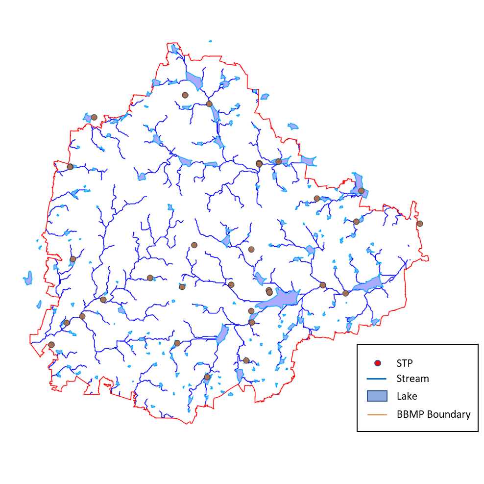
As can be seen above, these “randomly placed” STPs now make sense and fit into a wider interconnected network of lakes. The discerning reader might also notice that the streams seem to coalesce into larger networks. There is one on the South-west towards Kengeri on Mysore Road, fed by the streams and lakes of the West and south-west, and then there is the larger network leading East, fed by the lakes and streams of Central, South, South-East and East Bengaluru flowing towards Hoskote. The Northern network seems to be leading into this system further downstream outside of the city limits.
Indeed, Bengaluru has two predominant river systems.
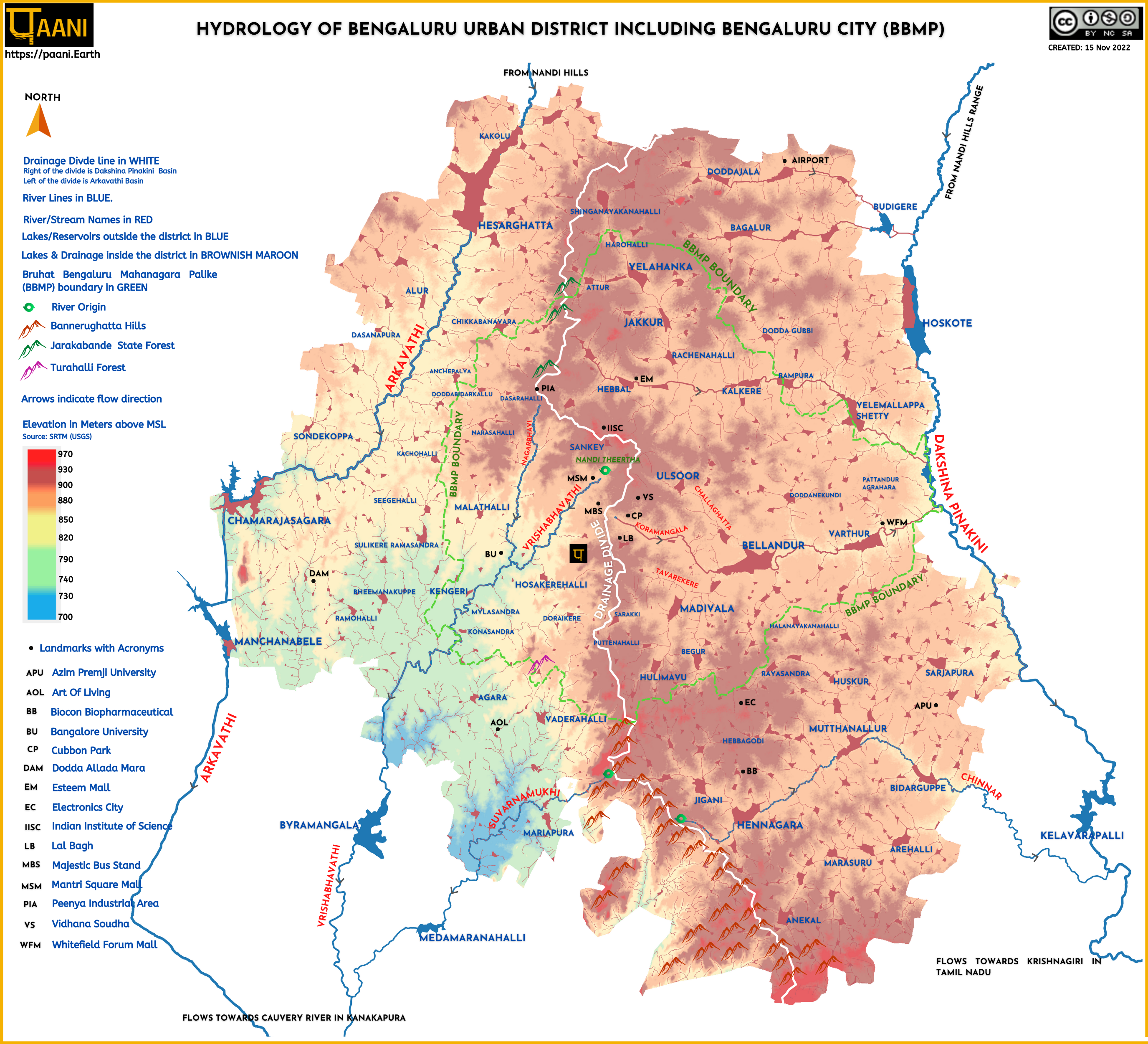
The one on the South-west is the Vrishabhavathi river, which joins river Arkavathi near Kanakapura town. The Arkavathi is a tributary of the Cauvery, merging into the latter at Mekedatu. The Vrishabhavathi was predominantly a “city” river, originating at the Nandi Teertha near Sankey tank. One of its major tributaries is the Nagarbhavi Thorai which originates near Peenya and joins the Vrishabhavathi near the Jnanabharathi Metro Station. What used to be a rain-fed seasonal river now carries the city’s waste. You can explore the river in detail with this beautiful map provided by Paani.earth, and read more about the river, its history and current status on their site.
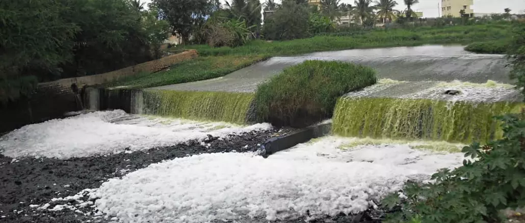
The second river system is the Dakshina Pinakini River, which originates in the Nandi Hills and flows to the Bay of Bengal after passing through Hosur, Thiruvannamalai and Cuddalore. Each of the stream systems seen above joins the river separately near Pattandur Agrahara. Bengaluru contributes another tributary to this river, known as the Chinnar, originating from Anekal, flowing through the Chandapura and Muthanallur lakes, and joining the Dakshina Pinakini south of Hosur town. Needless to say, all these three streams are heavily polluted, carrying an enormous amount of industrial and domestic waste.
The stream network that encompasses the major lakes of Bengaluru like Bellandur, Madiwala and Varthur is part of a hydroshed known as the Koramangala-Challaghatta valley, and a detailed map of this region, contributed by Paani.earth can be viewed here. You can read in detail about this watershed and what the major stressors are, here.
Why does a city like Bengaluru have two different river systems, each flowing in opposite directions? The topography of the city is the main contributor to this. The hydrology map above shows this divide in white. The city leans in different directions at different gradients on each side of this divide.
The elevated parts of the city are also a lot flatter, which explains the presence of so many more lakes in those parts of the city as against the fewer ones in the West-Southwest. It also explains why some parts of Bengaluru are more flood-prone than others. Finally, it also explains why the South-eastern parts of the sewage network need ISPS (Intermediate Sewage Pumping Stations) to pump the sewage while the south-west networks don’t.